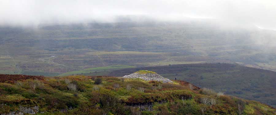
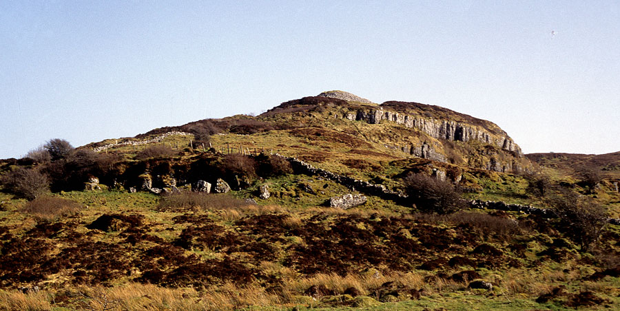
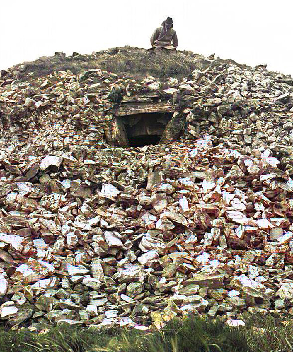
Cairn B at Carrowkeel perched above the craggy cliffs of Treanscrabbagh, with a person for scale. Kesh Corran is lost in the mists beyond; picture taken from below Cairn F.
Treanscrabbagh - Cairn B
Cairn B is the first and most dramatically sited cairn as you approach
Carrowkeel, perched atop the cliff-walled spur in Treanscrabbagh townland at 260 meters above sea level. Although it is difficult enough to reach this cairn, it is one
of the few here in a good state of repair. The townland Treanscrabbagh
means 'The Rough Third'.
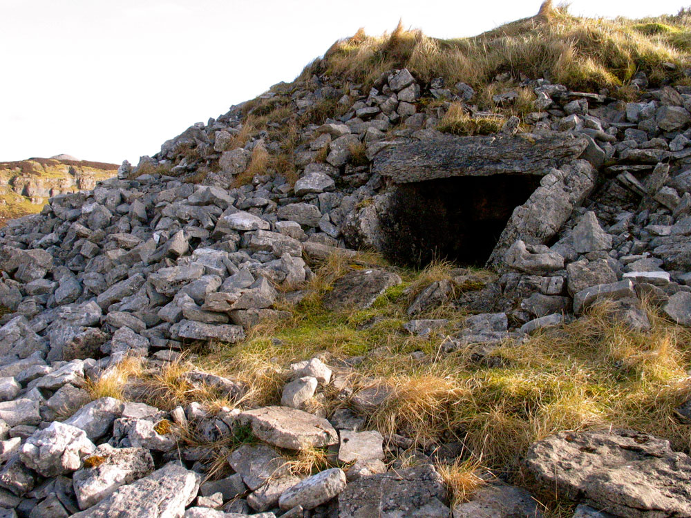
Cairn B is 22 metres in diameter, one of the larger cairns in the
Carrowkeel group. Cairns B and F
stand like sentinels on the cliffs above the Bricklieve Gap or Lough Availe,
which is also known as the Long Mile and the Devil's Bite. Below
the escarpment to the west are the remains of what may be a circular structure
or hut site, about 20 meters in diameter.
Cairn B has, apart from Cairns K and G, the most intact chamber to be found at Carrowkeel, a simple plan with no side recesses,
known as an undifferentiated chamber; the passage, about 3 metres long
widens to a small chamber. The entrance is high up in the body of the cairn. As with the other Carrowkeel cairns, the chamber is constructed with massive slabs of limestone and has two half-buried sill stones which divide the chamber from the passage. There is an unusual bulge or widening of the passage on the right-hand side of the chamber. Sill stones or thresholds are remarkably similar to sills found on modern sailing vessels. In ancient China, high thresholds were put into doorways to keep bad energies out of buildings. There is a small stone shelf or
bench, probably a modern construction, at the back of the chamber.
Local researcher Leo Regan has photographed the midsummer sunsets from this position. The sun sets into a dip or saddle to the west of Doomore in the Ox Mountains. There are several sites in this area that seem to be positioned with an aspect to the midsummer sunsets, such as Cairns A and G at Carrowkeel and Shee Lugh on Moytura across the lake.
Depending on where you sit at the back of the chamber, the passage is aligned across
the Collooney Gap towards Union Hill and Carrowmore.
If you sit tight up against the right hand wall, you can clearly see Knocknarea.
The passage is oriented too far to the north for the sun or moon to shine
into; and so it is quite likely that Cairn B is concerned with the setting
positions of some of the constellations as they set over Carrowmore.
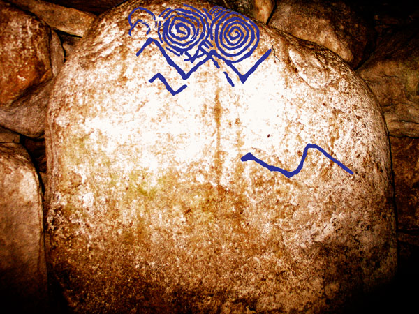
Megalithic art, recently discovered in Cairn B by Robert Hensey.
In 2010 a local archaeologist discovered the first panel of megalithic art recorded at Carrowkeel. The designs, 2 small spirals, are difficult to see with the naked eye, and were discovered by taking numerous photographs at slightly overlaying them. Spirals in megalithic art are thought to represent currents of energy moving theough the chamber. Cairn B is situated on a line between Cairn F and Treanscrabbagh, probably a leyline which extends further in both directions.
Cairn B at Carrowkeel perched above the craggy cliffs of Treanscrabbagh. There is a small cave amid the boulders to the lower left of the photo.
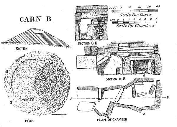
Cairn B: Macalister's comments
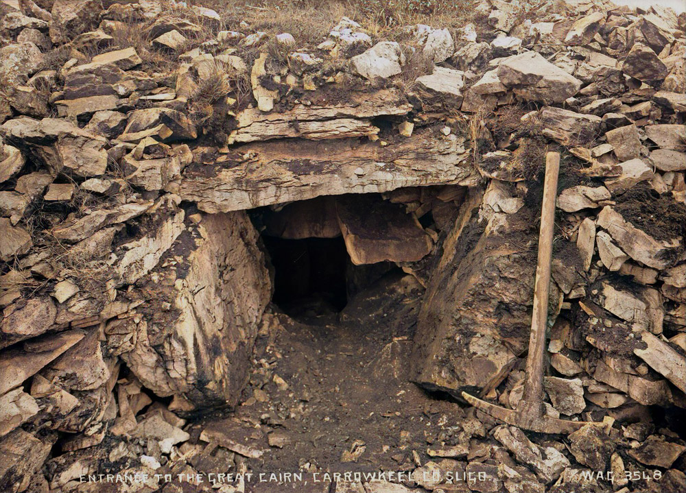
This fine carn stands near the northern extremity of the bold, cliff walled spur overlooking, on its eastern side, Lough Availe. The commanding situation of the earn is well shown in Plate XI, fig 2. The carn itself is the largest and best-formed of the entire series, with the exception of E. Its appearance, after the opening of the entrance, is shown in Plate XI, fig. 3. The entrance faces north, and was completely concealed: no trace or indication was visible before the excavation began, and in search for it we cut a trench completely round the carn. Even then it was only discovered afterwards almost by chance.
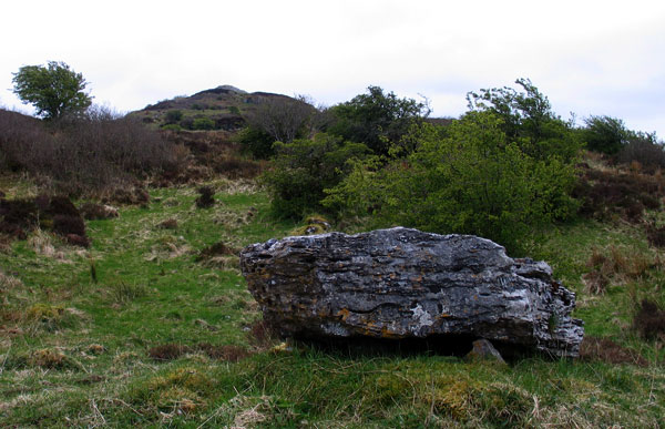
A small monument below Cairn B may be a boulder burial.
The structure measures 21 feet in height (15 feet if measured from the south side, as there the surface of the ground rises), and the diameter of the base is about 74 feet. The top is slightly flattened, and an Ordnance Survey beacon was erected upon it, the height of which is given as 936 feet. It is passing strange that the carn itself, though an object so conspicuous and striking, is not recorded on the map as an ancient monument.
The entrance, which is shown in Plate XI, fig. 4, is unusually high up on the side of the mound. It gives access to the chamber by a low passage, to which additional head-room is given by a drop in the floor, about a couple of feet in from the threshold. The chamber itself expands inward like a wedge in breadth, and to a lesser degree in height: the total length, measured from the back wall to the inner face of the sill at the entrance, is 9 feet 8 inches; the maximum height of the chamber is 5 feet 3 inches. The construction is very rough, and altogether unworthy of the fine external appearance of the carn: the massive boulders of which the walls and roof of the chamber are made are less carefully selected than in some other carns of the series.
Plan and elevation of Cairn B from 1911.
At the left-hand side of the chamber, at its inner end, is erected a cist, open at the side, in shape almost like a rude altar. This will be seen in the plans and sections of the structure (Plate XVII). It measures 3 feet 6 inches long, 2 feet broad, and 2 feet 2 inches high. Very probably it was intended originally as the burial-place proper, but as the interments increased in number it was found impossible to restrict them to this part of the structure: in point of fact, they were found actually to cover the floor of the whole chamber.
Round the outside of the carn there seems to have been a kerb of boulders a little larger than those of which the heap of stones itself is composed. From the disposition of the kerb-stones that remain (which will be understood from the plan of the carn on Plate XVII) we may perhaps infer that the present diameter is rather wider than the original intention of the builders. Round the south-west side, for nearly half the circumference of the carn, there runs a vertical joint in the stone-heap, with a truly formed face about 2 feet to 2 feet 6 inches in height. The position of this face is marked on the plan by heavier lines. It seems as though this had been erected as a retaining wall, and the stones piled behind it, a covering shell by which it was concealed being added later.
On the South-east side, close to the end of this masonry-face, two subsidiary cists were found, just under the surface of the mound. There can be little doubt that these were to the original erection of the carn. They were small boxes formed of stone slabs about 3 inches thick. The northern cist measured 1 foot 7 inches by 8 inches by 1 foot 4 inches high. The southern cist was smaller, and was much dilapidated. They contained nothing but a handful of burnt bone-dust. These cists, and the masonry face above described, were found in cutting the trench in search of the entrance.
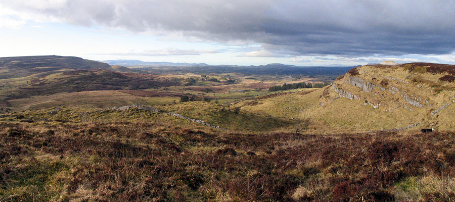
The
panorama from just south of Cairn B, which is perched above the cliffs
to the right. Kesh Corran and Treanmacmurtagh Cairn are to the right, Doomore, Croghaun and Knocknarea are visible on the horizon.