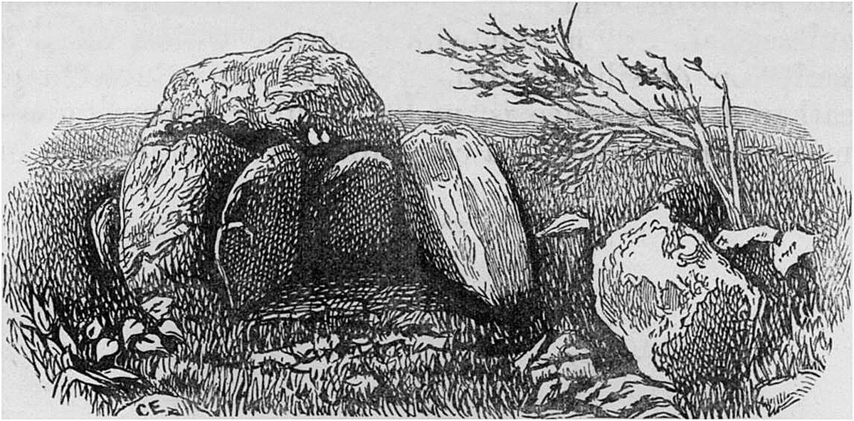
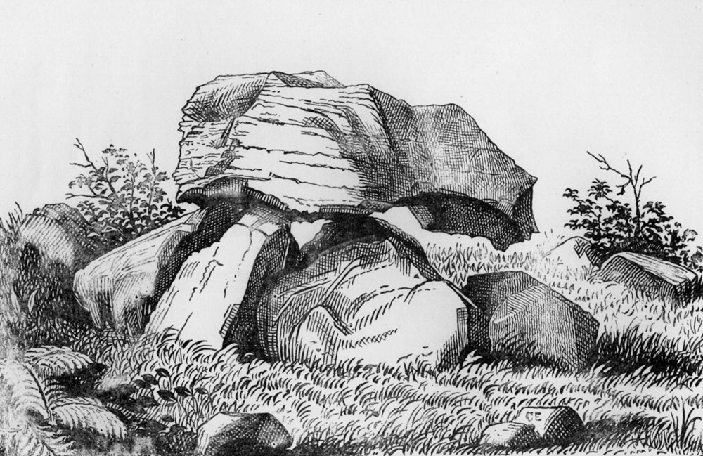
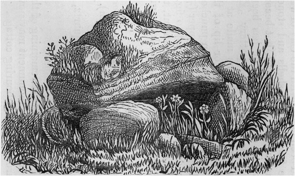
Carrowmore 13, the Druid's Altar illustrated by Charles Elcock in 1883.
NOTES ON THE PRE-HISTORIC MONUMENTS AT CARROWMORE, NEAR SLIGO:
BATTLE-FIELD OF THE NORTHERN MOYTURA
BY CHARLES ELCOCK.
ABOUT two and a half miles south-west of Sligo, the it road to Seafield passes through Carrowmore, in parish of Kilmacowen. It lies at the foot of Knocknarea, on the summit of which, at an elevation of 1078 feet above the sea, stands the large tumulus of the celebrated Queen Meave, which has served for many a century as a mark for mariners far out at sea. Carrowmore is slightly elevated above the surrounding country, and the surface is considerably undulating. The whole district, and for many miles in a line nearly north and south, inclining a little to the north-west and south-east, is covered with large, irregular, erratic blocks of coarse granite, dropped during the glacial period.
Charles Elcock.
Carrowmore may be regarded as classic ground, and the antiquarian may here revel for days in examining the various rude stone monuments, such as cromleacs, cists, stone circles, tumuli, cahirs, and forts which abound upon it. It is the site of the last and desperate battle fought by the Firbolgs,* about the year 30 B.C., just before they fled to Aranmor, where several of their stone cahirs still remain. At Carrowmore they made their last stand on the mainland of Ireland. The name of the Northen Moytura is given to the battle there fought, so as to distinguish it from a previous hardly-contested battle, fought about seven years earlier, on the plain of the Southern Moytura, close to Cong, at the north end of Lough Corrib. The monuments on the latter battle-field, though of a very different character to those at Carrowmore, are equally remarkable and interesting to the antiquary, and form a lasting memento of the fierceness of the struggle which, occupying several days, there took place. They are well described in Wilde’s “Lough Corrib,” the account being, perhaps, rather too florid for exactness.
* For an examination of the question as to whether there was a second battle of Moytura fought—which some query—see Jubainville’s Cycle Mythologique Irlandais, where the whole matter, with many references, is largely gone into.
The monuments on Carrowmore, of which, in 1883, sixty-three could be identified, are clustered together within a roughly oval space of about three-quarters of a mile long by less than half a mile wide. Near the centre of this is a large mound, of which the proper or original name is supposed to be lost. It is now called
Listoghil, which I was told on the spot, means rye-fort. But some little investigation kindly undertaken by my friend M. J. Ward, leads him to the conclusion that its derivation is from “lis”= fort, and “toghuil”= overthrow,—the Fort of Overthrow,—which possibly may be the “real, original” name, given to mark the spot of the decisive struggle.
Listoghil is a large heap of small stones, and for many years served as a quarry for road metal. However, one day when the workmen were carting the stones away, they came upon a huge flat stone resting on several others, “like a table,” and fear at once stopped any further destruction. It was evident that Listoghil was not a mere mound, but was one of the ancient monuments of which so many lie scattered around it. In 1837 the fort (as it is called) was about one hundred and fifty feet in diameter; in 1883 it is about one hundred and twenty; originally, it was probably about fifty feet high. Two stone circles formerly surrounded Listoghil, the outer circle consisting of one hundred and fifty stones. Some of these are still standing. From the top I counted twenty-two stone circles in sight, and six cromleacs, besides the one under my feet.
The large stone, “like a table,” which had become exposed, is the cap stone of a large cist, or cromleac. It is a flat limestone flag, about nine feet six inches square by one foot six inches thick. The height of the supporting stones I could not determine without excavation, which could not be undertaken. The interior of the cist or chamber is considerably filled up with boulders, which have been thrown in at the entrance to please the rustics by u the thundering noise they make.”The cist was opened“ some years ago ”by some distinguished man,” whose name I could not learn. He brought two men with him, and they dug down inside the chamber, and found “burnt human bones, charred wood, and a large stone spear-head,” which were carried off. All trace of them is now lost. I was told by the farmer, in whose fields most of these monuments stand, that burnt bones, “like horses’ bones,” are still found at Listoghil when a fall of the loose stones occurs.
Entrance to the cist cannot now be had without removing the stones lying about. By lying down I got my head inside, and thought I could detect some rudely incised circles on some of the stones, one circle being about ten inches in diameter. These need further investigation. Dr. Petrie’s* number for Listoghil is 51.
*Dr. Petrie visited and afterwards described the Carrowmore monuments, and gave numbers to each, so as to identify them afterwards. I have made use of these. but the route he took in going over the field is very difficult to follow so exactly as to be sure we are correct, and I am not certain whether, in some instances, I may not have mistaken his number. His letter on Carrowmore is dated “12th August 1837.” See his Life.
Walking from Sligo, the first cromleac which meets the eye is one close on the left or east side of the road. It formerly had a stone circle round it, which was cut through when making the road, and several of the stones were broken up to make the wall. Some may be seen in the wall, and one is still in the field, in situ. The cap stone very much resembles the top of a mushroom. It measures about twenty feet m circumference, and stands on six stones. One feature of this cromleac arrests the attention almost at the first glance. On the western side it has a sort of projecting porch-like entrance, formed by four stones—a peculiarity which is found on other cromleacs on Carrowmore. Dr. Petrie calls this No. 13.
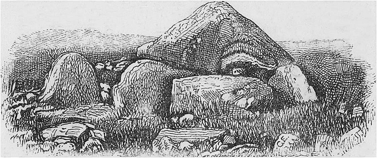
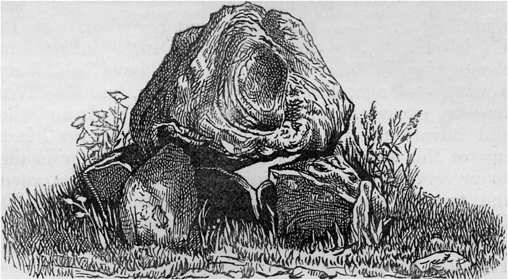
Carrowmore 52 illustrated by Charles Elcock during his 1883 visit.
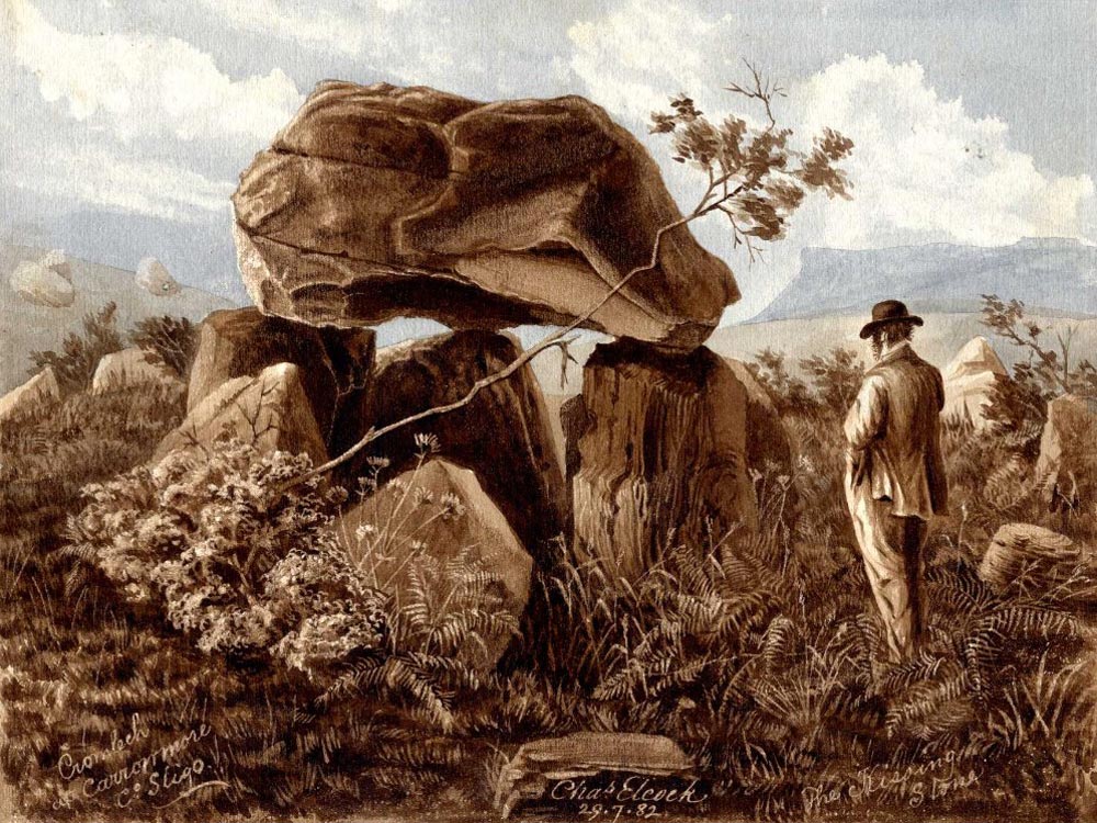
The Kissing Stone
On the west side of the road, and almost opposite the cromleac just mentioned, is a short lane leading to a field, near the highest part of which, but not visible from the main road, stands the largest of all the Carrowmore cromleacs. Its Irish name is “Leaba na Ffian,” which means the bed or grave of the warrior—a name which is given to each of the cromleacs in this group. The proverb as to the healing power of time could scarcely meet with stronger proof than that given by this Pagan monument, for the cause of the erection of this cromleac is now so completely forgotten in the neighbourhood, that that which is the result of bitter hatred is now known commonly as “The Kissing Stone.” Swains and maidens know the reason.
On the west side of the road, and almost opposite the cromleac just mentioned, is a short lane leading to a field, near the highest part of which, but not visible from the main road, stands the largest of all the Carrowmore cromleacs.
This cromleac is perfect, and stands from eight to nine feet high. The capstone rests on three of the six stones under it, and measures about twenty-three feet in circumference, being about ten feet long. A stone circle, nearly forty feet in diameter, still surrounds the cromleac, thirty-two stones, being in situ. The porch-like entrance is here seen also. This is the only cromleac of the group into which we can walk. Dr. Petrie calls this No. 7.
Almost due south of this cromleac, and being but a few yards away, easily seen from it, stands Dr. Petrie’s No. 4. This cromleac is quite perfect, and stands about five feet high. There are five supports for the capstone, which measures about fourteen feet in circumference. It stands near the middle of a field, and formerly had a stone circle around it about forty feet in diameter, consisting of forty large stones. When Dr. Petrie visited it in 1837, he found twenty-one of these still there. In 1883 these were all gone but one!
This cromleac is quite perfect, and stands about five feet high. There are five supports for the capstone, which measures about fourteen feet in circumference. It stands near the middle of a field, and formerly had a stone circle around it about forty feet in diameter, consisting of forty large stones. When Dr. Petrie visited it in 1837, he found twenty-one of these still there. In 1883 these were all gone but one!
On enquiring of the farmer before-mentioned how this was, he told me the twenty-one stones were all there still, but twenty had been buried by the man who held the farm before him, adding—“And he got no good by burying them.” The former tenant feared to destroy the stones, and so dug a large hole at the base of each, and then tipped twenty of them into the holes made, “and there they are still,” said my informant. He would have tipped over the last stone, but the agent, hearing what he was doing, came and stopped him just in time to save it. On account of the stones being “still there,” though invisible, I have ventured to name this“ The Cromleac of the Phantom Stones.” Although there are no stones placed as a porch outside the supporting stones, yet the idea of having a special entrance is evident in the construction of the entrance.
The remains of at least two very fine circles are near this cromleac, one of them containing a ruined cromleac, and the other having been a double circle, the outer circle being formed of very large stones. The chamber of the ruined cromleac was examined about fifty years ago by a gentleman named Walker, who found human remains in it. About a dozen were thus examined, and at least ten of them contained an interment of human remains, and in one instance the cromleac contained an urn, broken. This was found in Dr. Petrie’s No. 17—a double circle.
A beautiful if somewhat exaggerated atercolor of the Kissing Stone by Charles Elcock, dated 29 August 1882. The image enlarges the dolmen and reduces the scale of the human to child or hobbit or fairy size, and compresses the horizon.
Crossing the road again, there stands a little way south-west of the farm-house a large heap of stones which have been gathered off the land. Under this heap there is a perfect cromleac. It was covered when Dr. Petrie visited it. His number for it is 55. This ought to be uncovered by the Board of Works, under whose care these monuments are now placed.
Not far from this heap, down in the hollow near the house, stands Dr. Petrie’s No. 53. Nothing but the cromleac is now left, the circle formerly around it having disappeaied through “improvements” many years ago. The cromleac stands very low, and will soon be gone from sight, as it forms a good basis for a stone-heap, such as that at No. 55—It scarcely reached higher than the top of the oats by which it was surrounded when I saw it.
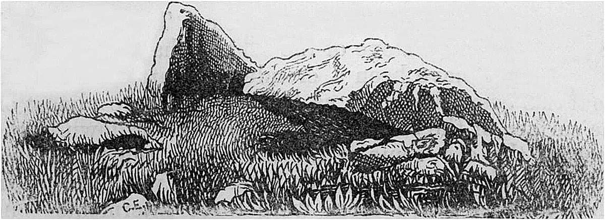
Charles Elcock's 1883 illustration of Carrowmore 48.
Double circles, with ruined cromleacs
In the next field to the south are a great number of circles: one in the east corner is formed of very large stones, and near it on the south-west is a fine large “giant’s grave,” or stone cist. Half of Listoghil stands in the field, and two cromleacs also.
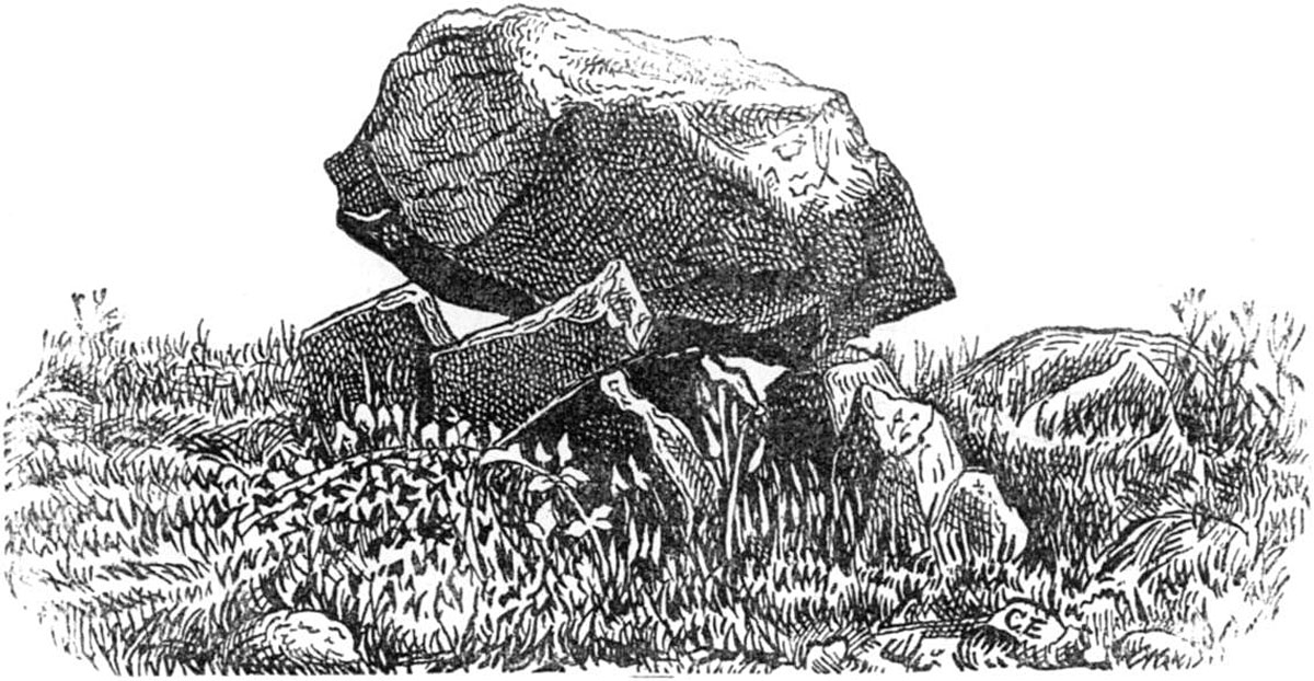
The nearest to us is Dr. Petrie’s No. 52. It is a large cromleac, with a conical capstone, flat underneath. Query, was it a double cromleac? The porch-like entrance is very marked, unless what looks like a porch may be the supports of a second cromleac, of which the cap stone is gone. A circle formerly surrounded this cromleac, but only one stone is now standing, and this is not in its original place. My informant once saw this stone being moved away, and he put it back as near as he could. There is a gentle incline of earth and stones up to the top of the supports of the cap stone/looking like an inclined plane, up which the cap stone was pushed into position, but I do not think it was formed for that purpose, though I could not learn whether it had been formed by throwing the stones there which were cleared out of the land.
Passing by Listoghil on our left, we see below us on the south, Dr. Petrie’s No. 48. This cromleac is perfect, the cap stone being about six feet square, but is nearly level with the ground. At a distance of thirty-eight feet from it stands a large solitary pointed stone, five feet high, the only one left of what must have been a magnificent circle, about eighty feet in diameter.
Double circles, with ruined cromleacs, are seen west of this in the same field.
Near the pond, at the bottom of the hollow, there is what appears to be a cist of unusual construction. There is a very large flag-like stone, flush with the surface, under which is a hollow space. I pushed my umbrella into it, through an opening on one side, and could swing it about. It was too dark inside to see anything..The peculiar feature is this:—On the top of:the flag, and placed round it, resting partly on the flag and partly on the surrounding soil, are a number of large stones, as if put there to keep the flag down and prevent its being raised. What can this be? I have never seen any similar structure.
Just over the wall, in the field at the top of the hill, is seen a very remarkable cashel or fort. It may be called roughly square, the sides being about one hundred and twenty feet long. The circumscribing walls are perhaps ten feet thick, and are made up of earth and massive stones. There are two entrances on opposite sides, north and south. The interior is divided by cross walls at right angles, and there appears to have been a cist or structure of some sort in it. There are a ditch and bank outside the wall. Altogether, it is very difficult to say what this really was, its appearance being so very different to what is usually found in forts, &c., and excavation would be necessary to settle the question whether this was a place of sepulture or not. Can it have been the great Firbolg stronghold?
Dr. Petrie numbers it 46.
Leaving the cashel and passing to the east, in the direction of Cloverhill, keeping near the wall, we soon come upon the last of the perfect cromleacs left on Carrowmore. Petrie s No. 37. It stands in the centre of a triple series of circles still there. The cromleac is small, the cap stone being about sixteen feet in circumference, and resting on five stones. The porch is very striking. The smallest circle is forty feet in diameter, and consists of small stones, much covered by the grass, so as to be nearly hidden. The middle arc e is eighty feet in diameter, and is formed of twelve large stones. The outermost circled one hundred and twenty feet in diameter and is composed of twelve much larger stones, some of which have been displaced.
This list mentions all the cromleacs which are perfect in 1883 Ruins and traces of others, with single, double, and even triple chambers in them, are numerous, no less than twenty being traceable, though many more formerly stood on Carrowmore.
Charles Elcock's 1883 illustration of Carrowmore 54.
There is one very fine circle not far from No. 37, stones of which stand seven feet above ground. have slipped from their places owing to the carting away of the gravel from the mound on which the circle stands. There are traces of cists or cromleacs within this circle, and on stamping the ground, it sounds as if hollow. Originally “over fifty” stones stood round the edge of this circle, which is seventy to eighty feet in diameter.
In a field about three hundred yards east of this circle, and on the left of the road to Cloverhill, is a stone cist. The tops of the stones are level with the ground. Some of the stones are carved with very rude scribings, an one at the entrance has on the edge what looks very much like an Ogham inscription. The drawings of these sculptures in Ferguson’s “Rude Stone Monuments” are not correct.
At the extreme northern end of the battle-field is to be seen the well of very fine water, never known to be dry, at which the Firholgs are said to have drunk on the day of the battle. Its Irish name is “Tober na Ffian,”—the Warrior’s Well.
A very short distance north of the Well stands a very remarkable solitary stone. It is called “Cloch-breac", The Grey [or Speckled] Stone. It is a flagstone standing on edge, measuring nearly ten feet above ground, and as wide as high : its thickness is about seven inches. It has a large quadrangular hole cut through it, large enough for a man to creep through with ease. It forms a “mearing point ” for the three adjoining parishes. Why it was erected, or when, is quite lost, and I could learn no tradition respecting it. Is it one of the old Pagan oath stones, such as the Maen-an-Thol, in Cornwall, or as “The Long Stone” at Minchinhampton, in Gloucestershire? Besides being used for swearing, such stones were used for curing children who had the measles, whooping-cough, &c., by passing the child through the hole! A superstition which it is hoped is now quite gone.
There is yet one more of the antiquities in Carrowmore which must be mentioned, although properly speaking not exactly belonging to the Moytura monuments. This is The Caltragh, a large Pagan burying ground, about a quarter of a mile due east of Cromleac No. 13. It may be seen from the field in which this cromleac stands, and from Listoghil. The Caltragh is an irregularly circular mound, about one hundred and fifty yards in diameter, enclosed by a wall. Some slight excavations made here and there many years ago, showed it to be full of human bones. The examination was difficult, owing to the prejudices of the neighbourhood. No burial has ever taken place there within the reach of tradition, and the ground is regarded as under a sort of taboo. Undoubtedly it dates from a very remote antiquity—probably much older than the Carrowmore monuments.
The whole of these monuments are included in the Act for the Preservation of Ancient Monuments.
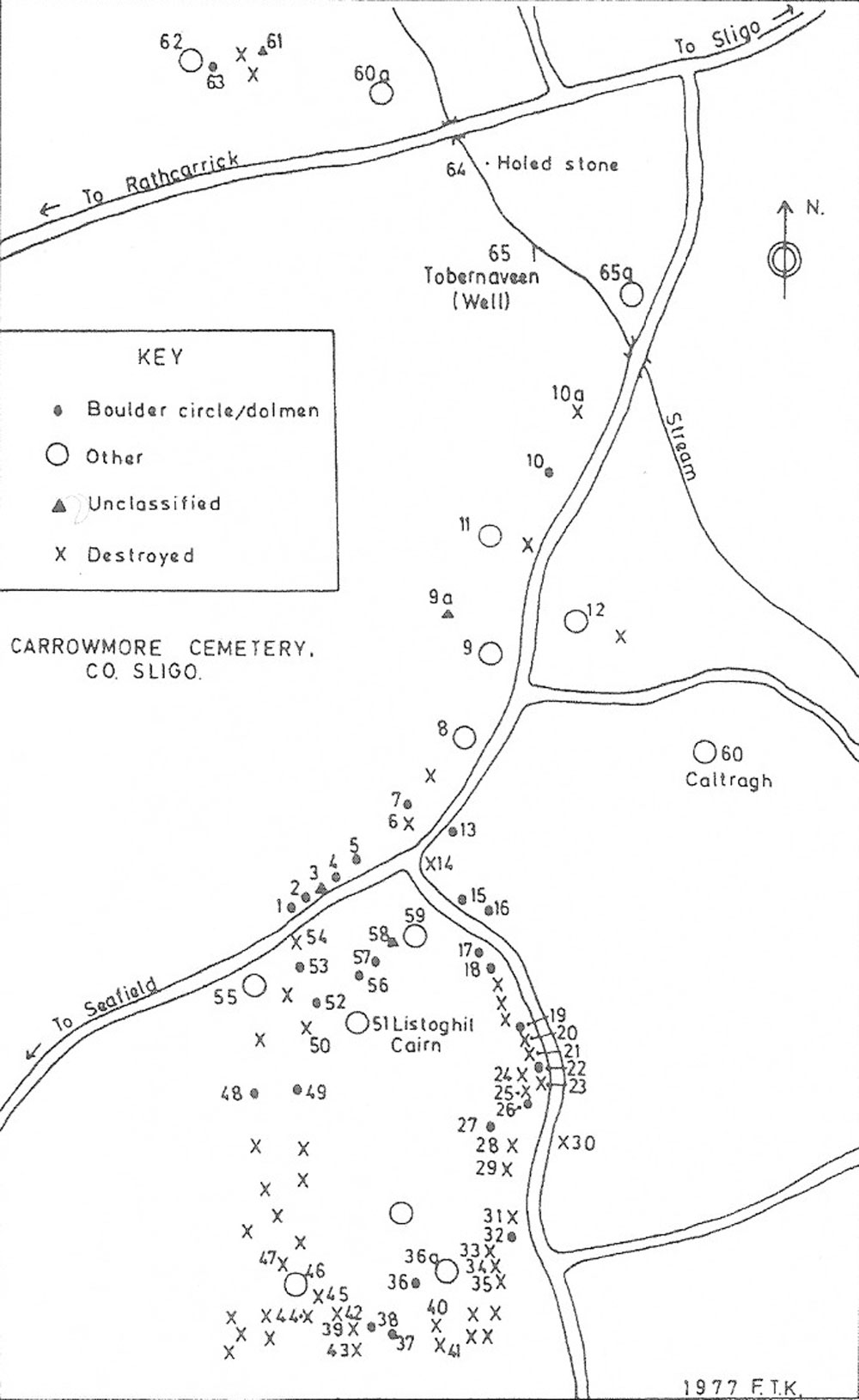
A 1977 map of Carrowmore.
There is now little doubt that the stone enclosures known as Druidical Circles, Druid’s Altars, and such like, are invariably sepulchral, with which the Druids had no sort of connection as to worship. The stone circles in all probability mark the burial places of the common soldiers who fell in the battle, and the cromleac in the centre, the grave of the chieftain—the “great man” who commanded them. Almost invariably, wherever examined, traces of human interments have been found in both. This is borne out by the ancient Irish name for all the Carrowmore monuments-the graves or beds of the Warriors.
Such of our members who may be in Sligo may count on a day of exceeding interest and instruction by paying a visit to Carrowmore. Out of Brittany, there is no other such collection of antiquities known to equal it in the world
Works of reference in connection with the subject.
Ferguson’s Rude Stone Monuments.
Dr. Petrie’s Life and Letters.
The Book of Fenagh.
Dunraven’s Notes on Early Irish Architecture.
Jubainville’s Le Cycle Mythologique Irlandais, chapters, vii., viii.
Wilde’s Lough Corrib.
Wood-Martin’s History of Sligo.
— This book contains the most recent information about Carrowmore.