Circles
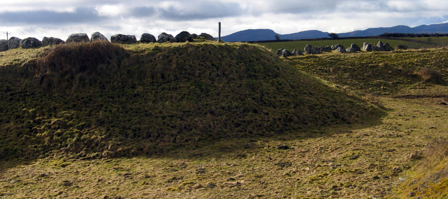
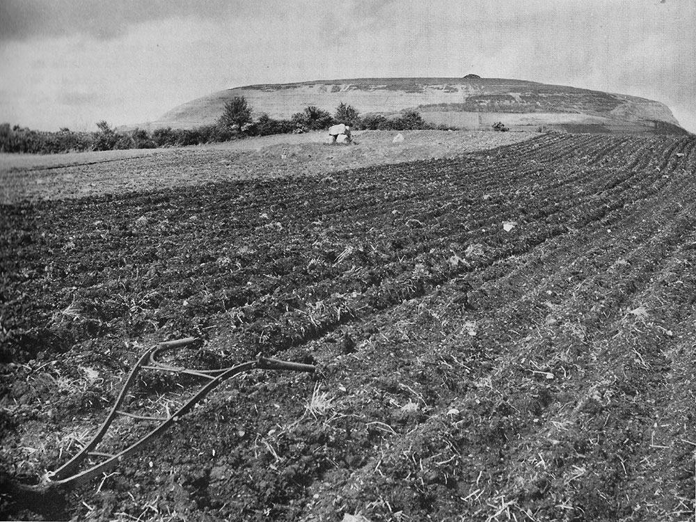
26 and 27 at the east side of Carrowmore were lucky to escape destruction. Circles 23, 25 and 25 were completely destroyed by this quarry. Doomore
cairn is on the large hill in the distance.
Destruction at Carrowmore
The dolmens and circles at Carrowmore have been subjected to a great deal of destruction and interference over the last 300 years. The monuments, locally considered to be the Cailleach's Beds or the Graves of Fallen Warriors, appear to have been respected by locals and remained largely intact until the 1830's. From the time of the Act of Union in 1801 quarrying and land clearance had become both more common and intensive as Sligo Town and the surrounding estates expanded.
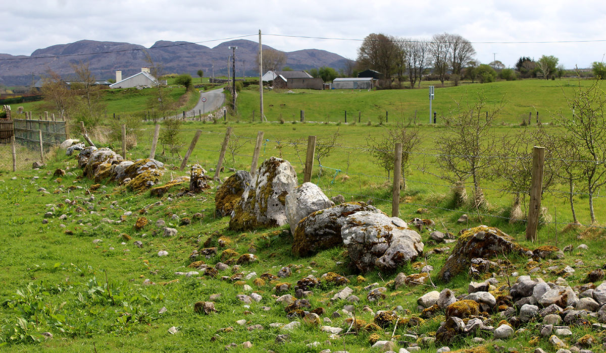
The fertile hill of Carrowmore, which was covered in a deep mantle of gravel from the ice age deposits was exploited as a quarry, and the huge gravel pits which were opened in 1906 are still vsible today where circles are said to have formerly stood. Circle 5 at Carrowmore, located between the Phantom Stones and the Kissing Stone, was marked as a semi-circle on Gabrial Beranger's 1779 map of Carrowmore. By the time George Petrie and the Ordnance Survey mapped the monuments in the late 1830's, the semi-circle and been removed and rearranged into a field boundary (below).
A good example of a destroyed Carrowmore monument - Circle 5 has been used to build a field boundary.
Colonial Landlords, who had inherited Irish estates and property after the wars territorial conquest over the previous few centuries, rented the land back to tenants, usually through the employment of agents or middlemen. There was a massive drive to improve the quality of the land and exploit natural resources, particularly after 1830, when many leases expired with the death of King George IV, and Landlords began have their lands cleared and fenced and 'Squared'. Another English monarch, William IV, died in 1837 and a fresh wave of destruction and wall-building was unleashed on Carrowmore.
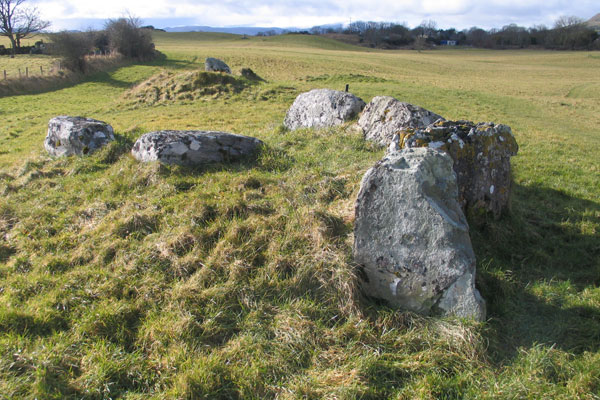
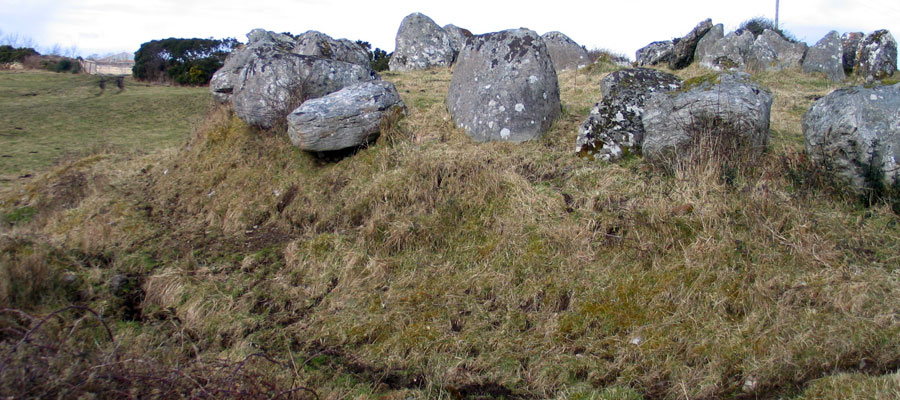
The largely destroyed monument at Site 58, thought by some be the remains of a wedge monument.
George Petrie was on hand in 1837 when several of the circles in the east side of Carrowmore had just been destroyed, and his notes are all the evidence we have in relation to several circles believed to have been destroyed at that time. Petrie's Carrowmore records are full of entries such as: "This circle, with its fine cromleac, was destroyed within the last week (i.e. August, 1837) by Mr. Chambers of Cloon Hill."
While Petrie was making records of the Carrowmore circles during the Ordnance Survey of 1837, he frequently lamented the rate of destruction which was taking place. He recorded the smashing of the boulder circle at Circle 54 so the stones could be used to build a field wall.
Rathcarrick, Sligo - August 11, 1837.
My dear Larcom,
I merely write you a line to say that after yesterdays investigation of the Sepulchral Circles at Carrowmore, I am far from done, though I have brought up my notes to 40 circles! I now verily believe there could not originally have been less than 200! But the destruction going on daily is horrible and if I do not work now, it would be too late to preserve a memorial of them in a short time. The peasentry generally have no reluctance to destroy them—on the contrary, are glad to get permission to clear the land of them. I am just now going there again.
Yours ever
most faithfully,
Goerge Petrie.
Stone circles were also smashed or removed at Circles 2, 5, 13, 49 and 52. The stones were used for wall-building materials.
The large cairn which had been added to Listoghil, the central monument at Carrowmore appears to have been added to the monument some 300 years after the chamber was constructed. This cairn seems to have survived largely intact until about 1840, when enough stones had been removed to expose the huge limestone slab covering the central chamber. Roger Walker is believed to have cleared out the chamber, throwing the human remains out around the monument. Before the site was excavated by the Swedish team, it was not obvious that the robbed cairn covered both a large stone circle and a huge platform.
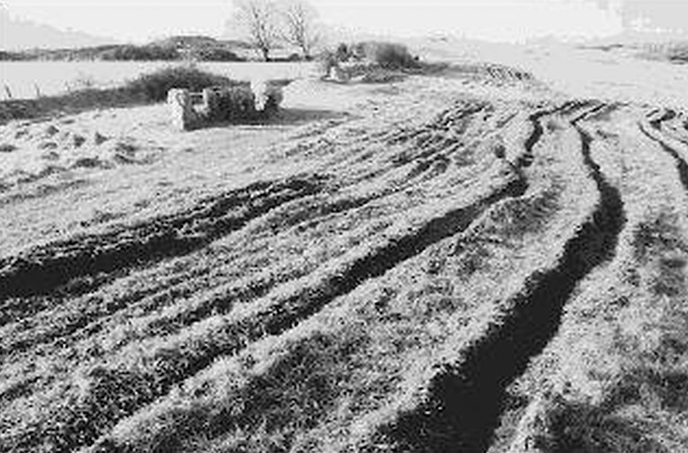
Extensive ploughing took place around Carrowmore 4, the Cromleach of the Phantom Stones, where the stone circle was buried around 1840. Photograph by Michael Herity.
A second large cairn was said to have been destroyed at Lachtreal hill about 250 meters and slightly more elevated than Listighil. It is interesting to note that the position of Listoghil is only 150 meters west of being exactly equidistant between the smaller west cairn on Carns Hill and the gigantic Queen Maeve's cairn on the mountain to the west.
Some thirty neolithic monuments remain at Carrowmore today. Petrie recorded sixty-five monuments originally, but today is is considered unlikely that there were ever more than forty circles. Their state of preservation varies considerably, from some sites, such as Circles 21 and 22, which are largely destroyed, to Circle 7 which is the most imposing and complete example of this type of monument remaining.
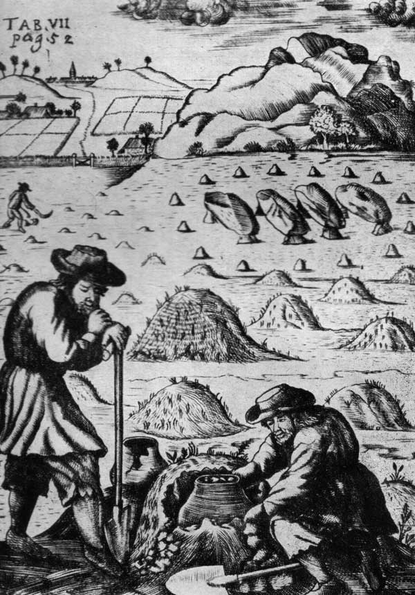
From a Dutch woodcut dated 1713: two men in are removing a pot from a burial mound. Behind them are other tumuli, while in the distance can be seen a gallery grave surrounded by a stone circle. From Joseph Raftery's 1953 book, Prehistoric Ireland.
A large swaith of sites were allegedly removed on the east, south and south-west portions of Carrowmore, although some researchers suspect that these circles may not have existed. There are several fields to the south of Carrowmore in Griague townland which are littered with enormous boulders, which were most likely never used for monuments, but remain as they were dropped by the glaciers.
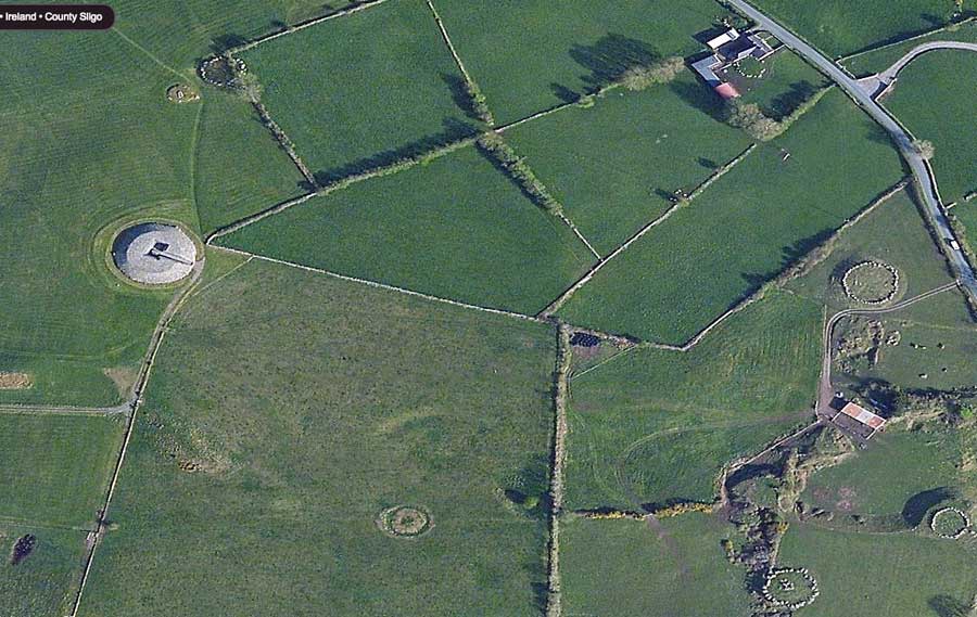
The Carrowmore circles viewed from above in Bing maps. The area to the lower right was extensively used as a gravel quarry, and large volumes of material was removed from the area around Circles 19, 26 and 27.
Later damage
In 1906 three thousand cartloads of gravel were taken from Carrowmore and used as building materials for the new Harper Campbell mill at the Victoria docks in Sligo. This accounts for the creation of four massive gravel quarry pits along the east side of Carrowmore, which stretch from the huge pit east of the Kissing Stone south to Leachtreal Hill by Circle 32.
The removal of the gravel was recorded in an article in the Sligo Champion in February 3rd, 1906:
Messers Harper Campbell, Ltd, obtained posession of the site in the third week in June last and at once commenced excavations for the foundations, etc, which were ready for the contractors to commence upon in the third week in August, and what was only a green field a few months ago has since been a busy hive of industry, giving much-needed employment to over fifty men per week. An idea of the amount of labour may be gathered from the fact that from the foundations and excavation for the resevoir close upon 3,000 loads of stuff have been carted away to the Marsh and Deep Water Embankment besides several hundred tons of stones quarried on the site for boundary walls, etc.
By the time the building is completed over 3,000 tons of gravel and sand will have been carted in from various pits at Carrowmore, the raising and carrying of which has benefited many of the farmers in that district.
Sligo Champion, 3rd Febuary 1906.
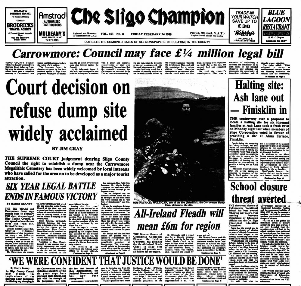
The Carrowmore Dump saga
In the early 1980's Sligo County Council came up with an amazing proposal to turn some of the large quarries at Carrowmore created in 1906, as mentioned above, into the county landfill dump.
Front page of the Sligo Champion, 24 February, 1989.
This insane proposal which suggested filling the quarries with litter, was contested by a group of concerned locals, and eventually — after several years the idea was overturned in the high court. The Swedish excavations, led by Professor Göran Burenhult, were hugely important in highlighting the significance of Carrowmore, and helping to overturn the Council's bid. The case was widely covered in the local and national newspapers. The Council's case was thrown out and the large and important megalithic complex at Carrowmore is now preserved.
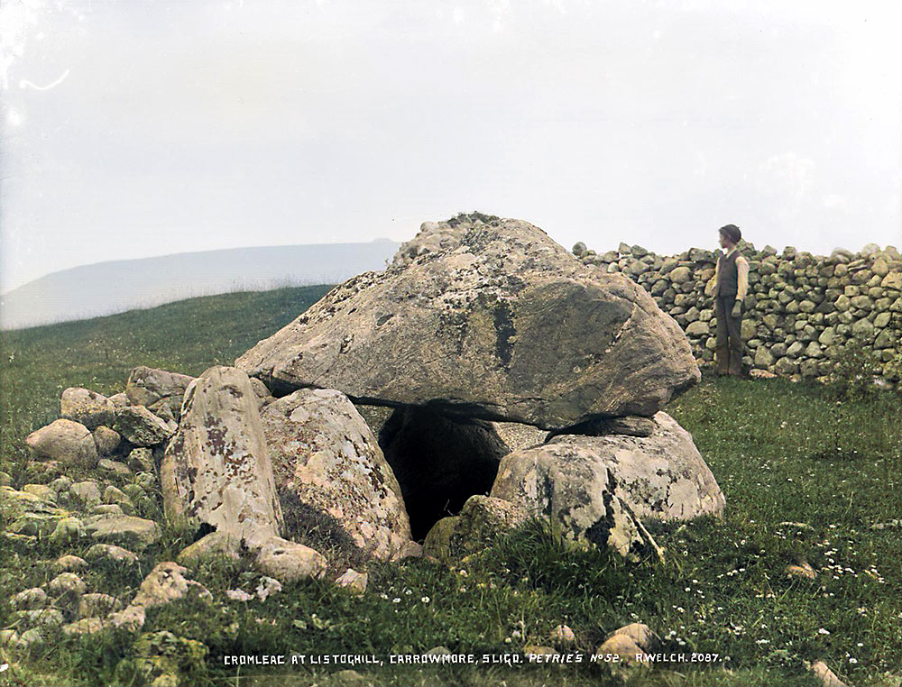
Circle 52 at Carrowmore photographed by Robert Welch in 1896. The large boulder circle surrounding this monument was broken up in the 1830's and the stones were used to build field walls.
Restoration Work
It would be wonderful to have all the circles at Carrowmore accessible and open to the public, as it is only
by walking a complete circuit of the entire complex that a visitor can get a true picture of the massive scale of the Carrowmore complex. After Burenhult's excavations, it was decided to tidy the site up and several changes were made. The large field currently visible at Carrowmore had been divided up into some fifteen smaller fields after the Enclosures Act of the late 1830's. These stone field walls were dismantled in the late 1990's, and the stones were used to construct the large modern cairn at Listoghil. This modern cairn has led to confusion amongst visitors to the site, and can be difficult to explain.
Circle 51, the central monument at Carrowmore was reconstructed in the late 1990's using material taken from demolished field walls, which had been built in the late 1830's.
Work at Carrowmore was investigated under Dáil scrutiny in 2001 as questions were raised about the reconstruction of Listoghil, the focal monument of the complex.
Work at Carrowmore under Dail scrutiny as questions raised.
THE people of Sligo wanted to know if the reinstatement works carried out at Carrowmore had been done for archaeological and heritage reasons, or if the project was tourist driven said Sligo/Leitrim Deputy, John Perry, in a Dail debate on the megalithic tombs at Carrowmore. Deputy Perry raised a series of questions with the Minister of State at the Department of Arts, Heritage, Gaeltacht and the Islands, Mary Coughlan T.D.
At the outset, Deputy Perry said the proper application of the National Monuments Acts, 1930-1994, where works proposed were at or near monuments protected under these acts, was welcome. However, he asked why they did not apply to Duchas and its agents at Carrowmore. He further asked why Duchas did not have an archaeologist present, under licence, during the works and who authorised the programme and what funds the works, which cost £50,000, were being paid out of.
The large ruts left by heavy machinery working on a reinstatement scheme at Tomb 51 at Carrowmore.
The current visitor centre at Carrowmore is housed in a cottage which appears on Gabriel Beranger's 1779 map of Carrowmore, which means the cottage is at least 250 years old. A family called the Gorevans lived in this cottage. A similar cottage, belonging to the Parke family stood beside Circle 1 across the road, and this cottage was demolished by the OPW in 1999.
Gravel quarrying on the west side of the huge Circle 27 has caused many of the massive stones to fall over.