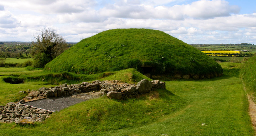
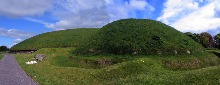
Satellite mound 2 at Knowth. In the foreground are the remains of a medieval house. Site 2 is surrounded by a bank and ditch.
Knowth - Site 2
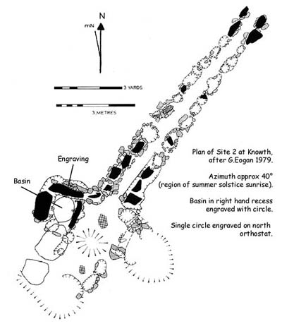
Site 2, the largest satellite at Knowth, would seem to be quite an important and overlooked monument in all the speculation and debate about the astronomical features
at Knowth. The mound is about twenty-two meters in diameter, similar in size to
the larger cairns at Carrowkeel and Loughcrew. The monument is oriented to the northeast,
approximately the region of the summer solstice sunrise and winter solstice
full moon rising positions. The passage and chamber measure thirteen meters
in length, and the chamber is cruciform in shape.
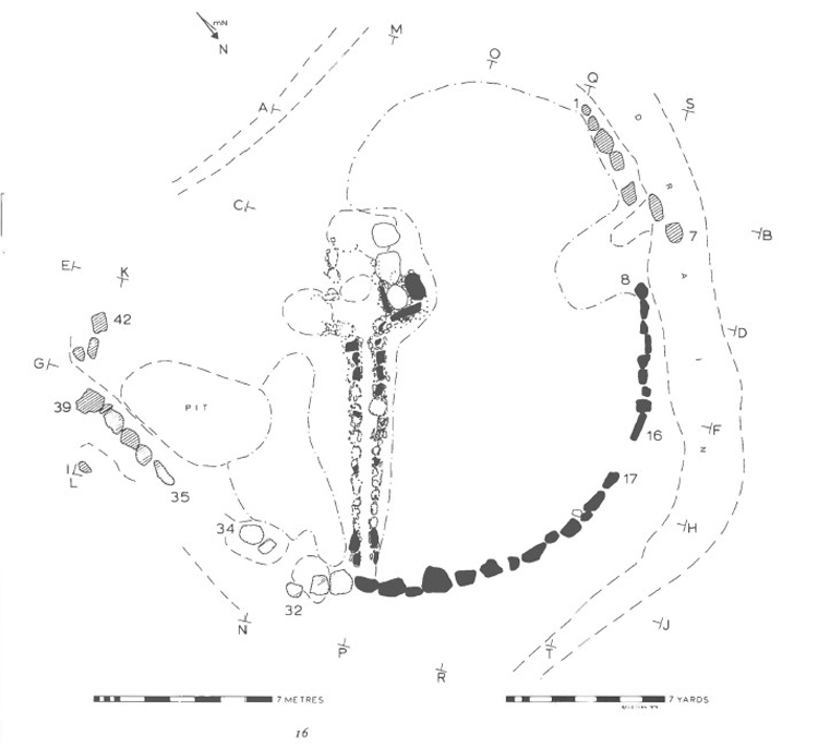
The diagram above is from George Eogan's 1976 book on the satellite mounds at Knowth, and shows that the left hand recess and the back wall of the chamber are destroyed, so we can't tell
if the right-hand recess is larger, as is usual in these monuments.
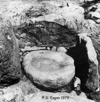
Stone Basin
The excavators found a basin in the right-hand recess of the chamber. There
is a picked line around the inside of the rim, and the basin looks as
though it was designed to hold liquid and not ashes. The orthostat on the north side
of the basin has a circle engraved on it which looks to be a fairly obvious
rising sun or full moon.
Right-hand recess with basin and circular engraving.
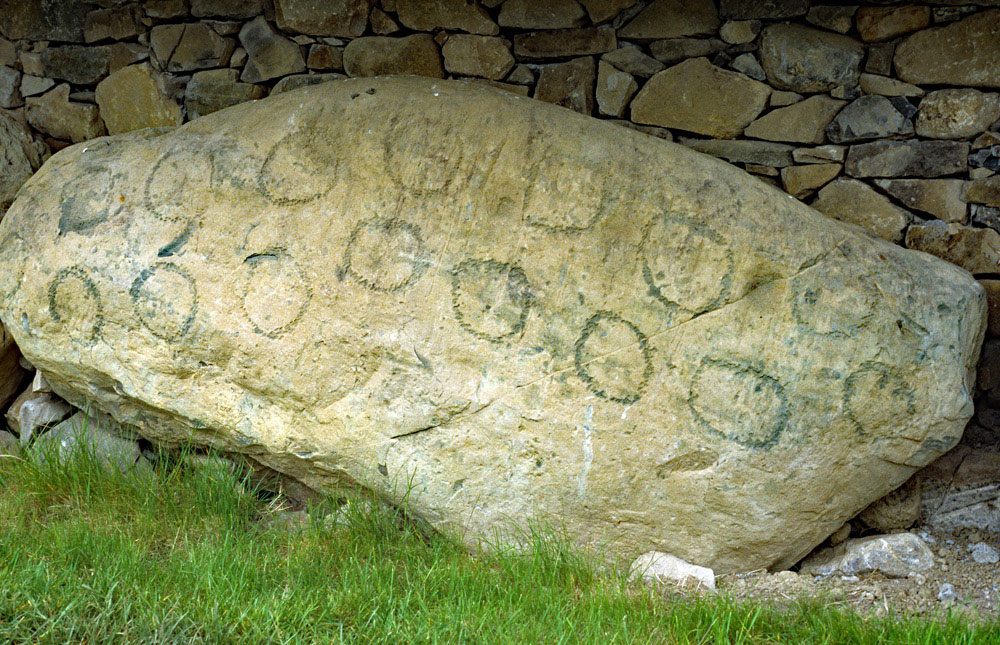
There are two more decorated in this monument, both of which which mark the point where the passage
ends and the chamber begins. The stone on the south side of the kerb of
the main mound, which is close by the entrance to this satellite, has
a number of circles which could represent and have been illuminated by
the rising midwinter full moons It certainly seems to be a counter or calendar of some sort.
What can only be described as lunar markings on the kerbstone closest to Site 2 at Knowth.
Megalithic Survey
Knowth cemetery, Tomb 2: Situated c. 3.5 meters south of the great mound, Tomb 1C. This is the remains of a kerbed mound (external diameter c. 22 meters), with orthostats and sockets representing a cruciform passage tomb (L c. 13 meters) opening to the north-east. An old ground surface was preserved within the kerb together with some of the mound (max. H 0.8 meters), which was a mixture of sods and boulder clay. A spread of charcoal in this produced a C14 date of 4158 +- 126 bp (2725 +- 153 cal. BC), which is clearly anomalous.
Of the 42 surviving kerbstones 22 were in position north-west to north-east, and most were set on the old ground surface. Of the 30 orthostats in the passage (Length 9.5 meters; Width 0.5-0.75 meters) only 10 (Height c. 1 meter) survived, and of the cruciform chamber (dimensions c. 4 meters north-east to south-west; c. 4 meters north-west to south-east) only the stones in the north-west or right-hand recess remained. This contained a stone basin (dimensions 1 meter x 0.8 meter; Height c. 0.48 meters; D 0.25 meters) with a picked line around its inner edge, and both cremated and unburned remains were confined to the chamber area.
Plan of Site 2 at Knowth.
The cremated remains consisted of two males and 12 other adults as well as four juveniles. One male and four other adults were represented amongst the unburned remains as well as those of four juveniles, and over half the remains were from the right-hand or north-west recess (Buckley et al. 2017, 302-06). The artefacts included a piece of Carrowkeel ware, a chalk ball and a hoard of 16 flint flakes stashed under one of the kerbstones.
Artistic motifs are present on one kerbstone (a circle), two orthostats from the passage (6 circles; chevrons and lozenges) just at the entrance to the chamber, and the backstone of the recess (circle with tail). Further work identified more displaced kerbstones, increasing the total to 68, one of which had a single motif in a simple circle, and a collapsed orthostat from the chamber had multiple circles on the underside (Eogan and Cleary 2017, 252).
Bayesian analysis of two dates produces a range of 3329-2929 cal. BC and 3348-3100cal. BC and there is a slightly later outlier of 3261-2901 cal. BC from a burial in the passage, but other determinations already published (Eogan 1984, 305) are anomalous and should be disregarded (Schulting et al. 2017, 351-2). The tomb was completely reconstructed with a full mound. (Eogan 1974, 58-66, site 13; 1984, 15-27, Site 2; 1986, 67-8)
Satellite 2 at Knowth viewed from the south, showing the ditch that was dug around the mound in the Iron age, some 3000 years after the mound was
constructed.